Monitoring & Management
European Frog-bit Reporting
Whether you are a manager, researcher, or an interested individual there are a variety of tools you can use to map, monitor, and/or report European frog-bit and other invasive species. There are also easily accessible mapping tools for those working in Great Lakes wetlands or who want to find invasive species organizations.
For each tool below we have identified its target audience and its potential uses but note that these may not apply in all cases—most tools are useable by anyone who is interested! Note that asterisks (*) denote aspects of tools that may only be accessible through payment, group membership, participation in special programs, or limited-service areas.
Are we missing a tool you think we should add? Let us know!
![]()
Delimiting European Frog-bit in the Great Lakes region
The delimitation app is designed to collect European frog-bit (EFB) surveillance data across the broad range of aquatic environments contained within the Great Lakes basin.
The app requires an ArcGIS Collector account. Request access to join the group here: https://bit.ly/EFBapp.* For more information, visit the EFB Collaborative’s ArcGIS Hub site.
Who is the target audience?
Anyone in the Great Lakes basin
What can you do?
- Report EFB findings
- Report monitoring locations
- View collected data points alongside observations from MISIN and GBIF
Invasive species reporting tools

Midwest Invasive Species Information Network (MISIN)
MISIN is a regional effort to develop and provide early detection and response resources for invasive species.
Who is the target audience?
Anyone in the Midwest
What can you do?
- Report invasives
- View distribution maps
- Request data
- Sign up for alerts
- Identification training
- Track treatments*
Early Detection & Distribution Mapping System (EDDMapS)
EDDMapS is a database of invasive species occurrences as reported by organizations and citizen scientists. There are several sub-categories on this platform, including EDDMapS Ontario.
Who is the target audience?
Anyone in the US/Canada
What can you do?
- Report invasives
- View distribution maps
- Download data
- Sign up for alerts
- Track infestations*
![]()
iMapInvasives
A GIS-based data management system used to assist citizen scientists and natural resource professionals working to protect our natural resources from the threat of invasive species. *Only available in participating jurisdictions (Arizona, Maine, New York, Oregon, Pennsylvania, and Saskatchewan).
Who is the target audience?
Anyone in the states listed above
What can you do?
- Report invasives*
- Record area searched*
- View distribution maps*
- Record treatments*
- Download data*
- Generate reports*
Wild Spotter
An invasive species reporting program for plants and animals in select US National Forests and National Grasslands co-led by Wildlife Forever, the University of Georgia, and the USDA Forest Service.
Who is the target audience?
Individuals and private groups in the US
What can you do?
- Report invasives*
- Register as a partner organization
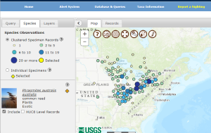
Nonindigenous Aquatic Species (NAS) Database
NAS is an aquatic invasive species database and alert system maintained by the US Geological Survey. Coverage is limited to the United States.
Who is the target audience?
Anyone in the US
What can you do?
- Report invasives
- View distribution maps
- Sign up for alerts
- Query database
- Produce graphs
- View maps of invasion risk (general and due to flood/storms)
Invasive species mapping tools
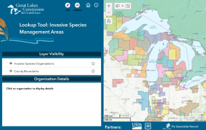
Great Lakes Invasive Species Organization Map
The Great Lakes Commission has created an interactive map of Great Lakes invasive species organizations operating at the local and state level.
Who is the target audience?
Individuals and managers in the Great Lakes
What can you do?
- Find the nearest invasive species organization
- Obtain organization contact information
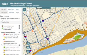
Michigan Wetlands Map Viewer
The Michigan Department of Environment, Great Lakes and Energy hosts this interactive map of Michigan wetlands, hydric soils, areas with wetland restoration potential, landcover, streams, floodplains, and other data.
Who is the target audience?
Individuals, managers, and researchers in Michigan
What can you do?
- View Michigan wetlands map
- Measure, create map buffers, draw polygons
- Share map or export data
![]()
Great Lakes Early Detection Network (GLEDN)
GLEDN is an invasive species network working to rapidly respond to new invasive species sightings in the Great Lakes states. GLEDN is connected to a variety of partner databases.
Who is the target audience?
Anyone in the Great Lakes
What can you do?
- Report invasives
- View distribution maps
Global Biodiversity Information Facility (GBIF) US data portal
This data portal serves as an access point to U.S. species occurrence data contributed to the Global Biodiversity Information Facility (GBIF). These data are collated from a number of different databases and publications in one convenient spot.
Who is the target audience?
Anyone in the US
What can you do?
- View map of invasive species occurrences
- Download data from GBIF
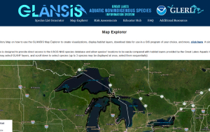
Great Lakes Aquatic Nonindigenous Species Information System (GLANSIS) Map Explorer
The GLANSIS Map Explorer provides users with direct access to the U.S. Geological Survey’s Non-indigenous Aquatic Species (NAS) database to show NAS locations within the eight Great Lakes states.
Who is the target audience?
Individuals and managers in the Great Lakes
What can you do?
- View map of NAS occurrences in the Great Lakes region
- Create visualizations, display habitat layers, and download data for use in a GIS program
Resources & Publications
Twitter Image: Protect Habitat
European Frog-bit Collaborative
Twitter Image: Preserve Habitat
European Frog-bit Collaborative
Status and strategy for European frog-bit (Hydrocharis morsus-ranae L.) management
Michigan Department of Environmental Quality and Central Michigan University