MONITORING & MANAGEMENT
European Frog-bit Monitoring
Detecting an invasive species early provides the most realistic chance for management activities to successfully eradicate the population. However, aquatic invasive plants are often cryptic and difficult to locate before widespread population growth. Detecting a species requires thorough surveillance of all preferred habitat for a given species. Documentation of surveillance efforts provides critical information on where the target species is found and where it is not.
The European Frog-bit Collaborative developed a series of ArcGIS tools to assist managers in the Great Lakes region with monitoring and delimiting European frog-bit.
Delimiting European frog-bit in the Great Lakes region
The delimitation app is designed to collect European frog-bit (EFB) surveillance data across a broad range of environments including large waterbodies such as coastal wetlands, inland lakes, or rivers. All data will be collected on the EFB Collab AIS Survey map in the ArcGIS Field Maps app. The application ensures standardized data collection across all locations surveyed for EFB.
The app requires an ArcGIS Collector account. Request access to join the group here: https://bit.ly/EFBapp.
Delimitation App Resources
Prioritizing monitoring locations
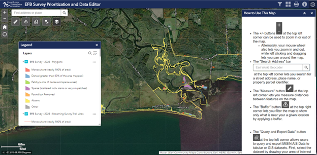
The Survey Prioritization and Data Editor web app serves dual purposes: to assist managers in planning European frog-bit survey locations by visualizing the existing data along with relevant ancillary datasets, and to give data contributors a way to edit survey data that they have collected and shared. Ancillary datasets in the map include information on protected areas, boat ramp locations, dams, wetlands, and watershed boundaries as well as relative wind exposure for Great Lakes sites. EFB observations in the MISIN database are also included. Data contributors can edit features they have already created and create new features. Contributors are only able to edit features created using their own account. Detailed instructions are included in the How to Use This Map pane, which can be reopened by clicking the info icon ![]() in the upper right corner.
in the upper right corner.
Resources & Publications
Twitter Image: Protect Habitat
European Frog-bit Collaborative
Twitter Image: Preserve Habitat
European Frog-bit Collaborative
Standard Treatment Impact Monitoring Protocol
European Frog-bit Collaborative